


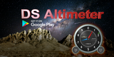
Altimeter & Altitude Widget


Altimeter & Altitude Widget का विवरण
DS Altimeter is an elevation meter, elevation logger, and altitude mapper. In addition to showing and optionally tracking your altitude, the app allows you to search the altitude for other locations as well.
You can select from the best sources of elevation data, including:
1. Location based altitude from NASA's Shuttle Radar Topography Mission.
2. Satellite based altitude (GPS altitude) corrected to height above mean sea level (AMSL).
3. Get actual land survey altitude values for your location from the United States Geologic Survey - available for customers in the contiguous United States, southern Canada and Mexico.
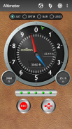
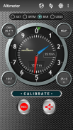
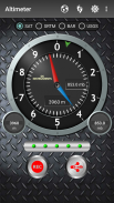
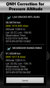
4. Devices equipped with a barometer sensor can also obtain pressure altitude which is converted to elevation above sea level. For the most precise readings, calibrate the pressure altitude.
The barometric altimeter offers 4 calibration tools:
1. Calibrate to the nearest airport. Choose your airport from the app's dynamic list of nearest airfields. Airfield data is usually updated every 20 - 30 minutes.
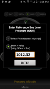
2. Enter a QNH value.
3. Enter the benchmark (known) altitude value for your location.
4. Calibrate the barometric altimeter against the SRTM altitude map.
DS Altimeter also works offline: barometric altitude and GPS altitude corrected to elevation above sea level do not require an internet connection.
NEW IN DS ALTIMETER:
● Photo altimeter. Snap a picture of your favorite high places with the altitude shown on your photograph.
● Easily get the altitude difference and grade between two locations by tapping 2 points on a map.
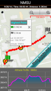
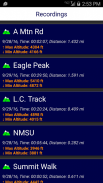
● Record altitude profiles and elevation tracks for your favorite journeys to the highlands, the lowlands and everything in-between!
● [SPECIAL] View your altitude recordings on the included maps with all track points displayed. Tap any track point and get the altitude at that point.
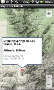
● Elevation Search: Enter a place name or address and get the altitude above sea level at that location.
Upgrade the application to pro and gain access to even more features including the Altimeter Widget.
Going skiing? Record your ski run with DS Altimeter, then view your ski trail with its elevation points on the included maps. Mininum and maximum altitude points for your run will be clearly shown.
Altitude mapping and bathymetry (lake and sea depths) are also included with DS Altimeter. Tap anywhere on a map to find altitude or water depth at that location.
● The application includes a detailed help section.
* The perfect altimeter for skiing, hiking, mountain climbing and other outdoor sports, boating, marine navigation and anytime you are curious about your elevation!
PERMISSIONS AND PRIVACY:
DS Software does not collect any personal information such as phone ID or user account information.
1. Location permission if required for GPS. GPS data is used for land survey altitude matching and to determine elevation above the Geoid (then corrected to elevation above sea level).
2. Photos/Media/Files permission is required for the screen capture procedure allowing you to share an image of your altitude result.
3. Wake-up phone (Wake-Lock) and Boot Permission are required to periodically refresh the values on the Altimeter Widget and to reactivate the Altimeter Widget when the phone is rebooted / restarted.
4. Internet and Network permissions are needed to access online land survey databases in Government facilities.
5. Billing permission is required to purchase the application for the purpose of activating the altimeter widget, remove advertising and to receive unlimited altitude-track recordings.
6. Vibrate permission - to vibrate the phone for important alerts.
डीएस Altimeter एक ऊंचाई मीटर, ऊंचाई लॉगजर, और ऊंचाई मैपर है। अपनी ऊंचाई को प्रदर्शित करने और वैकल्पिक रूप से ट्रैक करने के अलावा, ऐप आपको अन्य स्थानों के लिए ऊंचाई खोजने की अनुमति देता है।
आप ऊंचाई डेटा के सर्वोत्तम स्रोतों में से चुन सकते हैं, जिनमें निम्न शामिल हैं:
1। नासा के शटल रडार स्थलाकृति मिशन से स्थान आधारित ऊंचाई ।
2। सैटेलाइट आधारित ऊंचाई (जीपीएस ऊंचाई) औसत समुद्र स्तर (एएमएसएल) से ऊपर ऊंचाई तक सही है।
3। संयुक्त राज्य अमेरिका भूगर्भीय सर्वेक्षण से अपने स्थान के लिए वास्तविक भूमि सर्वेक्षण ऊंचाई मान प्राप्त करें - संयुक्त राज्य अमेरिका, दक्षिणी कनाडा और मेक्सिको में ग्राहकों के लिए उपलब्ध ।
4. बैरोमीटर सेंसर से लैस उपकरण भी दबाव ऊंचाई प्राप्त कर सकते हैं जो समुद्र तल से ऊपर की ऊंचाई में परिवर्तित हो जाता है। सबसे सटीक रीडिंग के लिए, दबाव ऊंचाई को कैलिब्रेट करें।
बैरोमेट्रिक altimeter 4 अंशांकन उपकरण प्रदान करता है:
1. निकटतम हवाई अड्डे पर कैलिब्रेट करें। ऐप की निकटतम एयरफील्ड की गतिशील सूची से अपना हवाई अड्डा चुनें। एयरफील्ड डेटा आमतौर पर हर 20-30 मिनट में अद्यतन किया जाता है।
2. एक क्यूएनएच मान दर्ज करें।
3. अपने स्थान के लिए बेंचमार्क (ज्ञात) ऊंचाई मान दर्ज करें।
4. एसआरटीएम ऊंचाई मानचित्र के खिलाफ बैरोमेट्रिक altimeter अंशांकन।
डीएस अल्टीमीटर भी ऑफलाइन काम करता है: समुद्री स्तर से ऊपर की ऊंचाई के लिए संशोधित बैरोमेट्रिक ऊंचाई और जीपीएस ऊंचाई को इंटरनेट कनेक्शन की आवश्यकता नहीं है।
डीएस अल्टीमेटर में नया:
● फोटो altimeter। अपनी तस्वीर पर दिखाए गए ऊंचाई के साथ अपने पसंदीदा उच्च स्थानों की एक तस्वीर स्नैप करें।
● मानचित्र पर 2 बिंदुओं को टैप करके आसानी से ऊंचाई अंतर और ग्रेड को दो स्थानों के बीच प्राप्त करें।
● अपनी पसंदीदा यात्राओं के लिए हाइलैंड्स, निचले इलाकों और बीच में सबकुछ के लिए ऊंचाई ऊंचाई प्रोफाइल और ऊंचाई ट्रैक रिकॉर्ड करें!
● [विशेष] प्रदर्शित नक्शे पर प्रदर्शित सभी ट्रैक पॉइंट्स के साथ अपनी ऊंचाई रिकॉर्डिंग देखें। किसी भी ट्रैक बिंदु पर टैप करें और उस बिंदु पर ऊंचाई प्राप्त करें।
● ऊंचाई खोज: स्थान का नाम या पता दर्ज करें और उस स्थान पर समुद्र स्तर से ऊपर की ऊंचाई प्राप्त करें।
एप्लिकेशन को समर्थक में अपग्रेड करें और Altimeter विजेट सहित और भी सुविधाओं तक पहुंच प्राप्त करें।
स्कीइंग जा रहे हैं? डीएस अल्टीमीटर के साथ अपनी स्की रन रिकॉर्ड करें, फिर शामिल स्काई पर अपने स्की ट्रेल को इसके ऊंचाई बिंदुओं के साथ देखें। आपके रन के लिए न्यूनतम और अधिकतम ऊंचाई बिंदु स्पष्ट रूप से दिखाए जाएंगे।
ऊंचाई मैपिंग और बाथमेट्री (झील और समुद्री गहराई) डीएस अल्टीमीटर के साथ भी शामिल हैं। उस स्थान पर ऊंचाई या पानी की गहराई को खोजने के लिए मानचित्र पर कहीं भी टैप करें।
● एप्लिकेशन में एक विस्तृत सहायता अनुभाग शामिल है।
* स्कीइंग, हाइकिंग, पर्वत चढ़ाई और अन्य आउटडोर खेल, नौकायन, समुद्री नेविगेशन और कभी भी आप अपनी ऊंचाई के बारे में उत्सुक हैं के लिए सही altimeter!
अनुमतियां और गोपनीयता:
डीएस सॉफ्टवेयर किसी भी व्यक्तिगत जानकारी जैसे फ़ोन आईडी या उपयोगकर्ता खाता जानकारी एकत्र नहीं करता है।
1. जीपीएस के लिए आवश्यक होने पर स्थान अनुमति। जीपीएस डेटा भूमि सर्वेक्षण ऊंचाई मिलान के लिए और जियोइड के ऊपर ऊंचाई निर्धारित करने के लिए उपयोग किया जाता है (फिर समुद्र तल से ऊपर की ऊंचाई पर सही)।
2. स्क्रीन कैप्चर प्रक्रिया के लिए फ़ोटो / मीडिया / फाइल अनुमति की आवश्यकता है ताकि आप अपने ऊंचाई परिणाम की एक छवि साझा कर सकें।
3. वेक-अप फोन (वेक-लॉक) और बूट अनुमति को समय-समय पर Altimeter विजेट पर मान रीफ्रेश करने और फ़ोन रीबूट / पुनरारंभ होने पर Altimeter विजेट को पुनः सक्रिय करने के लिए आवश्यक है।
4. सरकारी सुविधाओं में ऑनलाइन भूमि सर्वेक्षण डेटाबेस तक पहुंचने के लिए इंटरनेट और नेटवर्क अनुमतियों की आवश्यकता है।
5. altimeter विजेट को सक्रिय करने, विज्ञापन को हटाने और असीमित ऊंचाई-ट्रैक रिकॉर्डिंग प्राप्त करने के उद्देश्य से आवेदन खरीदने के लिए बिलिंग अनुमति की आवश्यकता है।
6. कंपन को अनुमति दें - महत्वपूर्ण अलर्ट के लिए फोन को कंपन करने के लिए।
Altimeter & Altitude Widget - Version 4.62
(03-11-2023)

Altimeter & Altitude Widget - एपीके जानकारी
एपीके संस्करण: 4.62पैकेज: com.discipleskies.android.altimeterLatest Version of Altimeter & Altitude Widget
अन्य संस्करण


Apps in the same category


